Geolocate

Houston topographic map

Click on the map to display elevation.

About this map

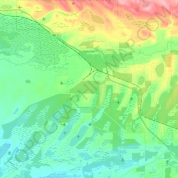
Name: Houston topographic map, elevation, terrain.

Location: Houston, Matanuska-Susitna, Alaska, 99694, United States (61.55963 -149.90364 61.65871 -149.72068)

Average elevation: 78 m

Minimum elevation: 42 m

Maximum elevation: 162 m

Other topographic maps

Click on a map to view its topography, its elevation and its terrain.

Talkeetna

United States > Alaska > Matanuska-Susitna > Talkeetna

Average elevation: 178 m

Matanuska

United States > Alaska > Matanuska-Susitna

Average elevation: 15 m

Halfway Lake

United States > Alaska > Matanuska-Susitna

Average elevation: 718 m

Sheep River

United States > Alaska > Matanuska-Susitna

Average elevation: 1,028 m

Gear up for your next adventure:

🔥Camping Stove - Portable stoves to cook outdoors with ease
🧰Emergency Multi-Tool - Compact multi-tool for outdoor survival
🧦Thermal Socks - Warm socks for winter hiking or camping
🚲Handlebar Phone Mount - View topographic-map.com live while cycling
🧥Softshell Hiking Jacket - The perfect balance of wind protection and breathability

As an Amazon Associate, this site earns from qualifying purchases at no extra cost to you.