
Make a donation
Gear up for your next adventure:
As an Amazon Associate, this site earns from qualifying purchases at no extra cost to you.
Wöbelsburg topographic map
Click on the map to display elevation.
Make a donation
Gear up for your next adventure:
As an Amazon Associate, this site earns from qualifying purchases at no extra cost to you.
About this map
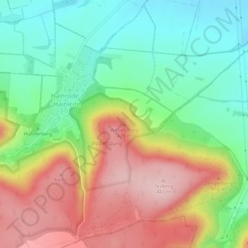
Name: Wöbelsburg topographic map, elevation, terrain.
Average elevation: 321 m
Minimum elevation: 227 m
Maximum elevation: 444 m
Make a donation
Gear up for your next adventure:
As an Amazon Associate, this site earns from qualifying purchases at no extra cost to you.
Other topographic maps
Click on a map to view its topography, its elevation and its terrain.
Kleinbodungen
Deutschland > Thüringen > Landkreis Nordhausen > Bleicherode
Kleinbodungen liegt im Tal der Bode, an der westlichen Grenze des Landkreises Nordhausen, etwa sechs Kilometer von der Stadt Bleicherode entfernt. Westlich des vormaligen Gemeindegebietes steigt das Gelände allmählich zum Ohmgebirge an, im Süden überragen die Höhen der Bleicheröder Berge das Tal und im…
Average elevation: 282 m
99752
Deutschland > Thüringen > Landkreis Nordhausen > Bleicherode > Wipperdorf
Average elevation: 291 m
Make a donation
Gear up for your next adventure:
As an Amazon Associate, this site earns from qualifying purchases at no extra cost to you.
Friedrichsthal
Deutschland > Thüringen > Landkreis Nordhausen > Bleicherode > Friedrichsthal
Average elevation: 244 m