Geolocate

Cannes-Écluse topographic map

Click on the map to display elevation.

About this map

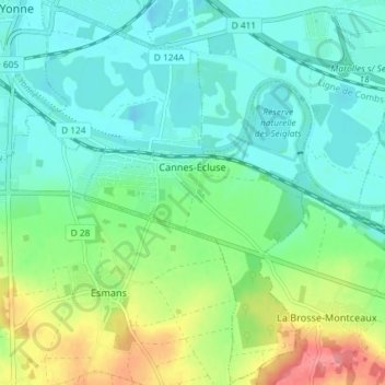
Name: Cannes-Écluse topographic map, elevation, terrain.

Location: Cannes-Écluse, Provins, Seine-et-Marne, Ile-de-France, Metropolitan France, 77130, France (48.33653 2.96342 48.38502 3.01459)

Average elevation: 67 m

Minimum elevation: 45 m

Maximum elevation: 124 m

Other topographic maps

Click on a map to view its topography, its elevation and its terrain.

Le Tillet

France > Ile-de-France > Seine-et-Marne > Reuil-en-Brie

Average elevation: 117 m

Freebooter Falls

France > Ile-de-France > Seine-et-Marne > Chessy

Average elevation: 117 m

Parc du Moulin

France > Ile-de-France > Seine-et-Marne > Chelles

Average elevation: 44 m

Gear up for your next adventure:

Camping Essentials - All-in-one gear for a comfortable camping trip
🛏️Sleeping Bag - Warm and compact sleeping bags for outdoor camping
🔭Compact Monocular - One-handed bird watching and trail spotting
🥾Hiking Shorts - Breathable shorts suitable for summer hikes
🥾Trail Running Shoes - Lightweight and durable shoes for trail running

As an Amazon Associate, this site earns from qualifying purchases at no extra cost to you.