Geolocate

Thatta topographic map

Click on the map to display elevation.

About this map
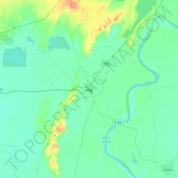
Name: Thatta topographic map, elevation, terrain.

Location: Thatta, Thatta Taluka, Thatta District, Banbhore Division, Sindh, 73130, Pakistan (24.58690 67.76403 24.90690 68.08403)

Average elevation: 13 m

Minimum elevation: 0 m

Maximum elevation: 74 m

Other topographic maps

Click on a map to view its topography, its elevation and its terrain.
Mirpur Sakro Taluka

Pakistan > Sindh > Thatta District

Average elevation: 14 m

Gear up for your next adventure:

🚲Heavy Duty Bike Lock - Secure your bike at the trailhead or during stops
🦌Outdoor Trail Camera - Monitor wildlife activity near your favorite spots
📷Outdoor Action Camera - Capture high-elevation views and rugged adventures
🧰Multitool Knife - Compact and versatile tool for outdoor use
🩹Moleskin Blister Pads - Direct protection for painful foot pressure points

As an Amazon Associate, this site earns from qualifying purchases at no extra cost to you.