
Make a donation
Gear up for your next adventure:
As an Amazon Associate, this site earns from qualifying purchases at no extra cost to you.
Ancenis topographic map
Click on the map to display elevation.
Make a donation
Gear up for your next adventure:
As an Amazon Associate, this site earns from qualifying purchases at no extra cost to you.
About this map
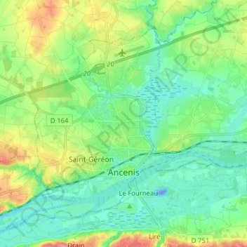
Name: Ancenis topographic map, elevation, terrain.
Average elevation: 23 m
Minimum elevation: -28 m
Maximum elevation: 77 m
Make a donation
Gear up for your next adventure:
As an Amazon Associate, this site earns from qualifying purchases at no extra cost to you.
Other topographic maps
Click on a map to view its topography, its elevation and its terrain.
La Marchanderie
France > Pays de la Loire > Loire-Atlantique > Ancenis-Saint-Géréon > Ancenis
Average elevation: 25 m
La Guère
France > Pays de la Loire > Loire-Atlantique > Ancenis-Saint-Géréon > Ancenis
Average elevation: 29 m
La Perrouinière
France > Pays de la Loire > Loire-Atlantique > Ancenis-Saint-Géréon > Ancenis
Average elevation: 24 m
Étang de la Guère
France > Pays de la Loire > Loire-Atlantique > Ancenis-Saint-Géréon > Ancenis > La Guère
Average elevation: 29 m
Make a donation
Gear up for your next adventure:
As an Amazon Associate, this site earns from qualifying purchases at no extra cost to you.