Geolocate

Magdeburg topographic map

Click on the map to display elevation.

About this map

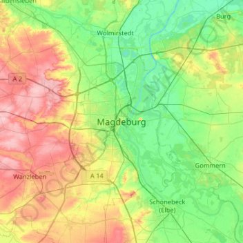
Name: Magdeburg topographic map, elevation, terrain.

Location: Magdeburg, Saxony-Anhalt, 39104, Germany (51.97159 11.47996 52.29159 11.79996)

Average elevation: 71 m

Minimum elevation: 32 m

Maximum elevation: 143 m

Other topographic maps

Click on a map to view its topography, its elevation and its terrain.

39110

Germany > Saxony-Anhalt > Magdeburg

Average elevation: 72 m

Gear up for your next adventure:

👟Leg Gaiters - Keep debris, mud, and snow out of your boots
🛰️Satellite Messenger - Emergency communication for areas with no cell service
🧥Thermal Layer - Insulating layer for cold outdoor conditions
🕯️Camping Lantern - Illuminates your entire campsite with high-efficiency LEDs
🛁Quick-Dry Microfiber Towel - Space-saving towel that dries rapidly on the move

As an Amazon Associate, this site earns from qualifying purchases at no extra cost to you.