Geolocate

Tanauan topographic map

Click on the map to display elevation.

About this map

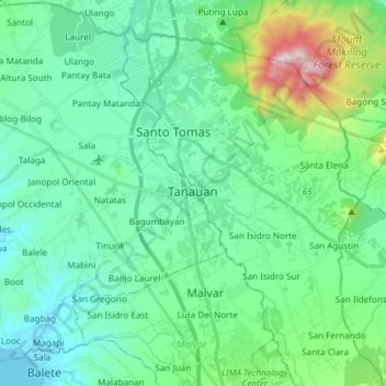
Name: Tanauan topographic map, elevation, terrain.

Location: Tanauan, Batangas, Calabarzon, 4232, Philippines (14.01232 121.04273 14.15695 121.16602)

Average elevation: 217 m

Minimum elevation: 2 m

Maximum elevation: 1,074 m

Other topographic maps

Click on a map to view its topography, its elevation and its terrain.

Balitoc

Philippines > Batangas > Calatagan

Average elevation: 13 m

Talisay

Philippines > Batangas > Lipa

Average elevation: 363 m

Poblacion

Philippines > Batangas > Taal

Average elevation: 26 m

Fabrica

Philippines > Batangas > Lobo

Average elevation: 20 m

Malaking Pulo

Philippines > Batangas > Tanauan

Average elevation: 178 m

Palsara

Philippines > Batangas > Balete

Average elevation: 58 m

Calle

Philippines > Batangas > Tanauan

Average elevation: 150 m

San Pedro II

Philippines > Batangas > Malvar

Average elevation: 174 m

Talahib Pandayan

Philippines > Batangas > Batangas City

Average elevation: 60 m

Dayap

Philippines > Batangas > Nasugbu

Average elevation: 43 m

Gear up for your next adventure:

🍽️Titanium Camping Spork - Ultralight and indestructible eating utensil
🦶Anti-Blister Balm - Prevents friction and hotspots during long ascents
🗺️Topographic Maps - Detailed maps to explore trails, mountains, and wilderness areas
🕶️Polarized Sunglasses - Protect your eyes with durable polarized lenses
🥤Collapsible Travel Cup - Saves space and weight in your mess kit

As an Amazon Associate, this site earns from qualifying purchases at no extra cost to you.