
Make a donation
Gear up for your next adventure:
As an Amazon Associate, this site earns from qualifying purchases at no extra cost to you.
Gersweiler topographic map
Click on the map to display elevation.
Make a donation
Gear up for your next adventure:
As an Amazon Associate, this site earns from qualifying purchases at no extra cost to you.
Gersweiler
Gersweiler liegt oberhalb einer durch die Saar geschaffenen breiten Talaue mit weiten Terrassenflächen am linken (südlichen) Saarufer. Der nördliche Talrand wird von einer langen Kette von Höhenvorsprüngen gesäumt. Südlich um Gersweiler ziehen sich die Höhen des St. Arnualer Stiftswaldes.
Make a donation
Gear up for your next adventure:
As an Amazon Associate, this site earns from qualifying purchases at no extra cost to you.
About this map
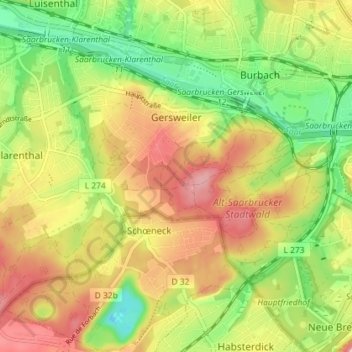
Name: Gersweiler topographic map, elevation, terrain.
Average elevation: 228 m
Minimum elevation: 160 m
Maximum elevation: 297 m
Make a donation
Gear up for your next adventure:
As an Amazon Associate, this site earns from qualifying purchases at no extra cost to you.
Other topographic maps
Click on a map to view its topography, its elevation and its terrain.
Staffelberg
Deutschland > Saarland > Regionalverband Saarbrücken > Saarbrücken
Average elevation: 331 m
Großer Homburg
Deutschland > Saarland > Regionalverband Saarbrücken > Saarbrücken
Average elevation: 259 m
Neu-Aschbach
Deutschland > Saarland > Regionalverband Saarbrücken > Saarbrücken
Average elevation: 233 m
Make a donation
Gear up for your next adventure:
As an Amazon Associate, this site earns from qualifying purchases at no extra cost to you.
Pfaffenkopf
Deutschland > Saarland > Regionalverband Saarbrücken > Saarbrücken
Average elevation: 294 m