Geolocate

Upper Egypt topographic map

Click on the map to display elevation.

About this map
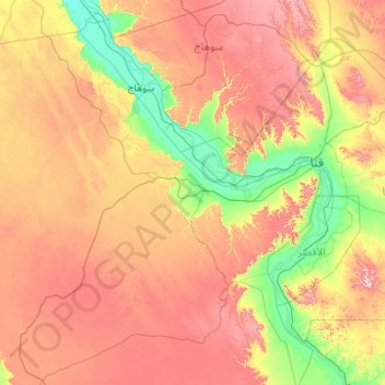
Name: Upper Egypt topographic map, elevation, terrain.

Location: Upper Egypt, New Valley, Egypt (25.00000 31.00000 27.00000 33.00000)

Average elevation: 314 m

Minimum elevation: 51 m

Maximum elevation: 789 m

Other topographic maps

Click on a map to view its topography, its elevation and its terrain.
Toshka

Egypt > New Valley

Average elevation: 197 m

Toshka Lakes

Egypt > New Valley

Average elevation: 162 m

Toshka

Egypt > New Valley

Average elevation: 194 m

White Desert

Egypt > New Valley

Average elevation: 170 m

Al Khargah City

Egypt > New Valley

Average elevation: 69 m

Toshka

Egypt > New Valley

Average elevation: 196 m

Jouhayna City

Egypt > New Valley

Average elevation: 66 m

Al Khargah City

Egypt > New Valley

Average elevation: 69 m

Gear up for your next adventure:

🔪Outdoor Multitool - Versatile tool for repairs and food prep in the wild
🧰Emergency Multi-Tool - Compact multi-tool for outdoor survival
🧦Merino Wool Socks - Moisture-wicking comfort for long-distance hiking
🥾Waterproof Hiking Boots - Essential footwear for rugged terrain and wet Canadian trails
🧼Biodegradable Camp Soap - Environmentally friendly cleaning for gear and body

As an Amazon Associate, this site earns from qualifying purchases at no extra cost to you.