Geolocate

Distrito Macarena topographic map

Click on the map to display elevation.

About this map

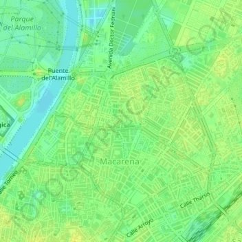
Name: Distrito Macarena topographic map, elevation, terrain.

Location: El Rocío, Distrito Macarena, Sevilla, Andalucía, España (37.40726 -5.98328 37.40901 -5.98034)

Average elevation: 13 m

Minimum elevation: 3 m

Maximum elevation: 20 m

Other topographic maps

Click on a map to view its topography, its elevation and its terrain.

Dehesa de Tablada

España > Andalucía > Sevilla

Average elevation: 8 m

Río Guadaira

España > Andalucía > Sevilla

Average elevation: 10 m

Jardines del Valle

España > Andalucía > Sevilla

Average elevation: 15 m

Gear up for your next adventure:

🔦LED Flashlight - Powerful and long-lasting flashlight for camping and emergencies
💡LED Headlamp - Hands-free illumination for night hiking and camping
🧥Ultralight Puffy Jacket - Maximum warmth that packs down to the size of an orange
🧥Softshell Hiking Jacket - The perfect balance of wind protection and breathability
🧥Waterproof Pants - Keep dry during rainy hiking conditions

As an Amazon Associate, this site earns from qualifying purchases at no extra cost to you.