Geolocate

Nuoro topographic map

Click on the map to display elevation.

About this map
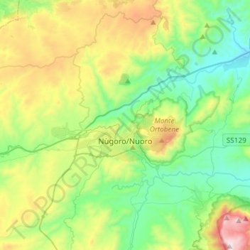
Name: Nuoro topographic map, elevation, terrain.

Location: Nuoro, Sardinia, 08100, Italy (40.25388 9.18302 40.41101 9.42608)

Average elevation: 497 m

Minimum elevation: 75 m

Maximum elevation: 1,452 m

Other topographic maps

Click on a map to view its topography, its elevation and its terrain.

Biddanoa

Italy > Sardinia > Nuoro > Torpè

Average elevation: 90 m

Cala Gonone

Italy > Sardinia > Nuoro

Average elevation: 141 m

Montelongu

Italy > Sardinia > Nuoro > San Giovanni

Average elevation: 12 m

Gorofai

Italy > Sardinia > Nuoro > Bitzi/Bitti

Average elevation: 591 m

Cala Luna

Italy > Sardinia > Nuoro > Durgali/Dorgali

Average elevation: 76 m

Pirastreri

Italy > Sardinia > Nuoro > Thiniscole/Siniscola

Average elevation: 59 m

Cala Luna

Italy > Sardinia > Nuoro > Durgali/Dorgali

Average elevation: 76 m

Gear up for your next adventure:

🛌Insulated Sleeping Pad - Critical thermal barrier between you and the cold ground
🧢Hiking Hat - Sun-protective and breathable hats for long treks
👖Convertible Hiking Pants - Zip-off legs to adapt to changing weather conditions
🔋Lithium AA Batteries - Long-lasting power that performs in extreme cold
🩹Compact First Aid Kit - Pre-packed essentials for common trail injuries

As an Amazon Associate, this site earns from qualifying purchases at no extra cost to you.