
Garzweiler topographic map
Interactive map
Click on the map to display elevation.
About this map
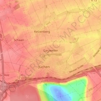
Name: Garzweiler topographic map, elevation, terrain.
Average elevation: 70 m
Minimum elevation: -34 m
Maximum elevation: 98 m
Other topographic maps
Click on a map to view its topography, its elevation and its terrain.
Hochneukirch
Deutschland > Nordrhein-Westfalen > Jüchen
Hochneukirch, Jüchen, Rhein-Kreis Neuss, Nordrhein-Westfalen, Deutschland
Average elevation: 85 m
Bedburdyck
Deutschland > Nordrhein-Westfalen > Jüchen
Bedburdyck, Jüchen, Rhein-Kreis Neuss, Nordrhein-Westfalen, Deutschland
Average elevation: 64 m