
Ngorongoro topographic map
Interactive map
Click on the map to display elevation.
About this map
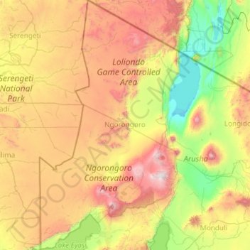
Name: Ngorongoro topographic map, elevation, terrain.
Location: Ngorongoro, Arusha, Northern Zone, Tanzanie (-3.62725 34.88083 -1.68655 36.10470)
Average elevation: 1,480 m
Minimum elevation: 594 m
Maximum elevation: 3,583 m
Other topographic maps
Click on a map to view its topography, its elevation and its terrain.
Makao Mapya
Tanzanie > Arusha > Makao Mapya
Makao Mapya, Arumeru, Arusha, Northern Zone, Tanzanie
Average elevation: 911 m
Mt Kitumbeine
Mt Kitumbeine, Monduli, Arusha, Northern Zone, Tanzanie
Average elevation: 2,694 m
Ol Doinyo Lengai
Ol Doinyo Lengai, Ngorongoro, Arusha, Northern Zone, Tanzanie
Average elevation: 2,369 m
Lac Natron
Lac Natron, Ngorongoro, Arusha, Northern Zone, Tanzanie
Average elevation: 861 m
Ndutu Ranger Post
Ndutu Ranger Post, Ngorongoro, Arusha, Northern Zone, Tanzanie
Average elevation: 1,616 m
Mount Meru
Mount Meru, Arumeru, Arusha, Northern Zone, Tanzanie
Average elevation: 3,884 m