
Make a donation
Gear up for your next adventure:
As an Amazon Associate, this site earns from qualifying purchases at no extra cost to you.
Oiticica topographic map
Click on the map to display elevation.
Make a donation
Gear up for your next adventure:
As an Amazon Associate, this site earns from qualifying purchases at no extra cost to you.
About this map
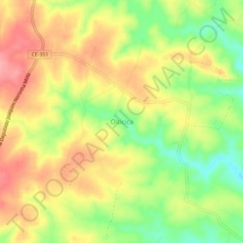
Name: Oiticica topographic map, elevation, terrain.
Average elevation: 558 m
Minimum elevation: 504 m
Maximum elevation: 604 m
Make a donation
Gear up for your next adventure:
As an Amazon Associate, this site earns from qualifying purchases at no extra cost to you.
Other topographic maps
Click on a map to view its topography, its elevation and its terrain.
Cococi
Parambu é um município brasileiro do estado do Ceará. Localiza-se na Microrregião do Sertão de Inhamuns, sua população em 2016 era de 31.213 habitantes. Distante cerca de 406 km da capital Fortaleza, onde o acesso é feito através das rodovias BR-020 e CE-277. A uma altitude de 496 metros acima do nivel do mar.
Average elevation: 417 m