Geolocate

Thigpen topographic map

Click on the map to display elevation.

About this map

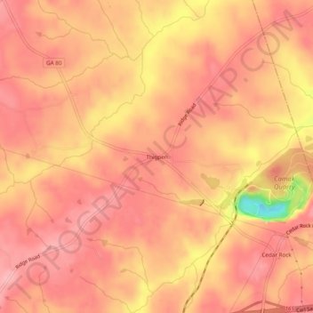
Name: Thigpen topographic map, elevation, terrain.

Location: Thigpen, Warren County, Georgia, United States (33.49514 -82.65374 33.53514 -82.61374)

Average elevation: 145 m

Minimum elevation: 46 m

Maximum elevation: 175 m

Other topographic maps

Click on a map to view its topography, its elevation and its terrain.

Warrenton

United States > Georgia > Warren County

Average elevation: 151 m

Norwood

United States > Georgia > Warren County

Average elevation: 180 m

Camak

United States > Georgia > Warren County

Average elevation: 169 m

Gear up for your next adventure:

🧣Merino Neck Gaiter - Protects against wind, sun, and cold at high altitudes
🥾Mountaineering Boots - Supportive boots for climbing and high-altitude hiking
🥾Light Trekking Boots - Supportive boots for multi-day treks
🥾Mountain Trail Shoes - High-traction shoes for mountain trails
🛌Down Sleeping Bag - Superior warmth-to-weight ratio for cold nights

As an Amazon Associate, this site earns from qualifying purchases at no extra cost to you.