Geolocate

Lastanosa topographic map

Click on the map to display elevation.

About this map

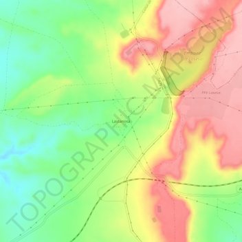
Name: Lastanosa topographic map, elevation, terrain.

Location: Lastanosa, Sariñena, Los Monegros, Huesca, Aragón, España (41.83182 -0.10274 41.87182 -0.06274)

Average elevation: 390 m

Minimum elevation: 317 m

Maximum elevation: 463 m

Other topographic maps

Click on a map to view its topography, its elevation and its terrain.

Pantano de San Juan

España > Aragón > Los Monegros > Sariñena

Average elevation: 300 m

Embalse de Lasesa

España > Aragón > Los Monegros > Sariñena

Average elevation: 430 m

Gear up for your next adventure:

🎒Fully Waterproof Backpack - Total protection for photography gear and electronics
Bushcraft Tarp - Versatile emergency shelter or gear protection
🔦UV Flashlight - Detect minerals or specific insects in the dark
🧰Multitool Knife - Compact and versatile tool for outdoor use
🧭GPS Handheld Device - Reliable GPS navigation for outdoor adventures

As an Amazon Associate, this site earns from qualifying purchases at no extra cost to you.