Geolocate

Neturlim topographic map

Click on the map to display elevation.

About this map

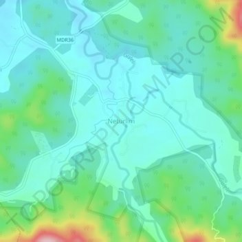
Name: Neturlim topographic map, elevation, terrain.

Location: Neturlim, Sanguem, South Goa, Goa, India (15.07122 74.19710 15.11122 74.23710)

Average elevation: 92 m

Minimum elevation: 43 m

Maximum elevation: 273 m

Other topographic maps

Click on a map to view its topography, its elevation and its terrain.

Salaulim Dam

India > Goa > Sanguem > Sanguem

Average elevation: 39 m

Maulinguem

India > Goa > Sanguem

Average elevation: 101 m

Sanvordem

India > Goa > Sanguem

Average elevation: 28 m

Gear up for your next adventure:

💧Reusable Water Bottle - Durable water bottles for hydration on trails
🚲Heavy Duty Bike Lock - Secure your bike at the trailhead or during stops
👖Convertible Hiking Pants - Zip-off legs to adapt to changing weather conditions
🔦UV Flashlight - Detect minerals or specific insects in the dark
🥾Lightweight Hiking Boots - Boots for comfort and mobility on long hikes

As an Amazon Associate, this site earns from qualifying purchases at no extra cost to you.