Geolocate

Andahua topographic map

Click on the map to display elevation.

About this map

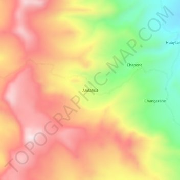
Name: Andahua topographic map, elevation, terrain.

Location: Andahua, Callalli, Caylloma, Arequipa, Perú (-15.61192 -71.22945 -15.57192 -71.18945)

Average elevation: 4,750 m

Minimum elevation: 4,436 m

Maximum elevation: 4,995 m

Gear up for your next adventure:

🦶Anti-Blister Balm - Prevents friction and hotspots during long ascents
🥾Hiking Shoes - Durable and comfortable shoes for trail hiking
🥾Waterproof Hiking Shoes - Durable shoes for wet and rugged trails
🩹Compact First Aid Kit - Pre-packed essentials for common trail injuries
Camping Coffee Maker - Brew fresh coffee anywhere on the topographic map

As an Amazon Associate, this site earns from qualifying purchases at no extra cost to you.