
Thank you for supporting this site ❤️
Make a donation
Make a donation
Gear up for your next adventure:
As an Amazon Associate, this site earns from qualifying purchases at no extra cost to you.
Fiames topographic map
Click on the map to display elevation.
Thank you for supporting this site ❤️
Make a donation
Make a donation
Gear up for your next adventure:
As an Amazon Associate, this site earns from qualifying purchases at no extra cost to you.
About this map
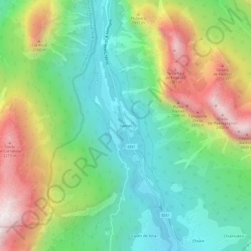
Name: Fiames topographic map, elevation, terrain.
Location: Fiames, Cortina d'Ampezzo, Belluno, Veneto, 32043, Italië (46.55228 12.09782 46.59228 12.13782)
Average elevation: 1,667 m
Minimum elevation: 1,246 m
Maximum elevation: 2,405 m
Thank you for supporting this site ❤️
Make a donation
Make a donation
Gear up for your next adventure:
As an Amazon Associate, this site earns from qualifying purchases at no extra cost to you.