Geolocate

Tontitown topographic map

Click on the map to display elevation.

About this map

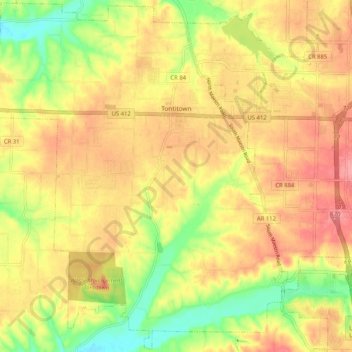
Name: Tontitown topographic map, elevation, terrain.

Location: Tontitown, Washington County, Arkansas, 72770, United States (36.12108 -94.30370 36.20276 -94.20099)

Average elevation: 385 m

Minimum elevation: 332 m

Maximum elevation: 425 m

Other topographic maps

Click on a map to view its topography, its elevation and its terrain.

Durham

United States > Arkansas > Washington County

Average elevation: 411 m

Sonora

United States > Arkansas > Washington County

Average elevation: 388 m

Pinnacle

United States > Arkansas > Washington County

Average elevation: 360 m

Wyman

United States > Arkansas > Washington County

Average elevation: 377 m

Canehill

United States > Arkansas > Washington County

Average elevation: 446 m

Savoy

United States > Arkansas > Washington County

Average elevation: 348 m

Sunset

United States > Arkansas > Washington County

Average elevation: 628 m

Strickler

United States > Arkansas > Washington County

Average elevation: 486 m

Hogeye

United States > Arkansas > Washington County

Average elevation: 414 m

Gear up for your next adventure:

Tent Footprint - Protect tent floor and increase durability
Backpacking Tent - Lightweight tent for long-distance hiking trips
🐕Hiking Dog Pack - Let your canine companion carry their own water and food
❄️Traction Ice Cleats - Slip-on spikes for icy trails and winter hiking
🗺️Topographic Maps - Detailed maps to explore trails, mountains, and wilderness areas

As an Amazon Associate, this site earns from qualifying purchases at no extra cost to you.