Geolocate

Pisgah topographic map

Click on the map to display elevation.

About this map

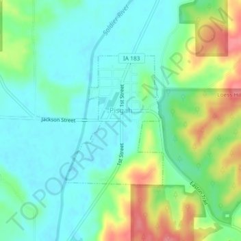
Name: Pisgah topographic map, elevation, terrain.

Location: Pisgah, Harrison County, Iowa, United States (41.82316 -95.93445 41.83770 -95.91986)

Average elevation: 342 m

Minimum elevation: 317 m

Maximum elevation: 398 m

Gear up for your next adventure:

Camping Essentials - All-in-one gear for a comfortable camping trip
💡Portable Camping Lamp - Rechargeable lamp for campsite lighting
🧥Thermal Layer - Insulating layer for cold outdoor conditions
🧥Fleece Jacket - Warm and lightweight jacket for layering
🥾All-Terrain Hiking Boots - Versatile boots for varied hiking conditions

As an Amazon Associate, this site earns from qualifying purchases at no extra cost to you.