Geolocate

Castletown topographic map

Click on the map to display elevation.

About this map

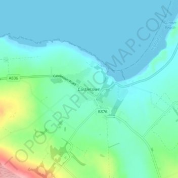
Name: Castletown topographic map, elevation, terrain.

Location: Castletown, Highland, Scotland, KW14 8UE, United Kingdom (58.57247 -3.40722 58.61247 -3.36722)

Average elevation: 25 m

Minimum elevation: -1 m

Maximum elevation: 135 m

Other topographic maps

Click on a map to view its topography, its elevation and its terrain.

Loch Ness

United Kingdom > Scotland > Highland > Dores

Average elevation: 340 m

Strathnairn

United Kingdom > Scotland > Highland > Daviot

Average elevation: 268 m

Whitebridge

United Kingdom > Scotland > Highland

Average elevation: 223 m

Glen Coe

United Kingdom > Scotland > Highland > Glencoe

Average elevation: 414 m

Gear up for your next adventure:

🧴Waterproofing Spray - Restore the DWR coating on jackets and tents
🧴Insect Repellent - Protect yourself from bugs during outdoor adventures
🥾Mountain Hiking Boots - High-traction boots for rocky terrain
🦟Insect Repellent - Keep mosquitoes and black flies away in wooded areas
Lightweight Camping Tent - Portable shelter optimized for Canadian backcountry camping

As an Amazon Associate, this site earns from qualifying purchases at no extra cost to you.