
Pinecrest Lake topographic map
Interactive map
Click on the map to display elevation.
About this map
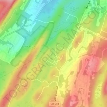
Name: Pinecrest Lake topographic map, elevation, terrain.
Average elevation: 277 m
Minimum elevation: 202 m
Maximum elevation: 349 m
Other topographic maps
Click on a map to view its topography, its elevation and its terrain.
Echo Lake
United States > New Jersey > Passaic County > West Milford
Echo Lake, West Milford, Passaic County, New Jersey, 07480, United States
Average elevation: 305 m
Moe
United States > New Jersey > Passaic County > West Milford
Moe, West Milford, Passaic County, New Jersey, 07421, United States
Average elevation: 354 m
Oak Ridge
United States > New Jersey > Passaic County > West Milford
Oak Ridge, West Milford, Passaic County, New Jersey, 07438, United States
Average elevation: 277 m
Norvin Green State Forest
United States > New Jersey > Passaic County > West Milford
Norvin Green State Forest, West Milford, Passaic County, New Jersey, United States
Average elevation: 262 m