
Bullet topographic map
Click on the map to display elevation.
Bullet
The municipality is located in the Vaudois Jura. The town lies on the end moraine of the ice age era Rhone glacier. It consists of the village of Bullet (elevation 1,143 m (3,750 ft)) and the hamlets of Les Rasses, Les Cluds, La Crochère, Les Crosats and La Frétaz.
About this map
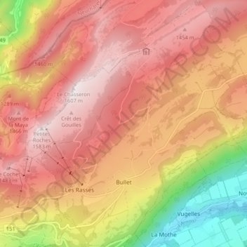
Name: Bullet topographic map, elevation, terrain.
Location: Bullet, District du Jura-Nord vaudois, Vaud, Switzerland (46.81655 6.52223 46.87143 6.59386)
Average elevation: 1,173 m
Minimum elevation: 514 m
Maximum elevation: 1,590 m