
Telangana topographic map
Interactive map
Click on the map to display elevation.
About this map
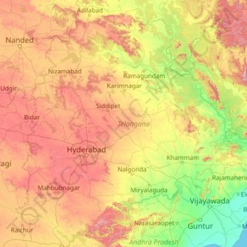
Name: Telangana topographic map, elevation, terrain.
Location: Telangana, India (15.83635 77.23659 19.91730 81.32113)
Average elevation: 320 m
Minimum elevation: 0 m
Maximum elevation: 1,262 m
Other topographic maps
Click on a map to view its topography, its elevation and its terrain.
Gurudev Nagar
India > Telangana > Gurudev Nagar
Gurudev Nagar, Boath mandal, Adilabad, Telangana, India
Average elevation: 467 m