
De Beque topographic map
Click on the map to display elevation.
About this map
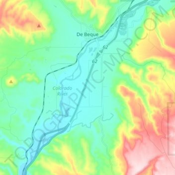
Name: De Beque topographic map, elevation, terrain.
Location: De Beque, Mesa County, Colorado, United States (39.25691 -108.22222 39.35346 -108.16632)
Average elevation: 1,597 m
Minimum elevation: 1,476 m
Maximum elevation: 1,889 m
Other topographic maps
Click on a map to view its topography, its elevation and its terrain.
Fruita
United States > Colorado > Mesa County
The original town site was planned for 80 acres (32 ha) with a park in the middle. The first water reached the town from the Colorado River in 1907. By 1909, the town center was linked with electricity. In the 1930s, Fruita participated in several government projects, including the Grand Valley Resettlement…
Average elevation: 1,400 m
Grand Mesa
United States > Colorado > Mesa County
The Grand Mesa is a large mesa in western Colorado in the United States. It is the largest flat-topped mountain in the world. It has an area of about 500 square miles (1,300 km2) and stretches for about 40 miles (60 km) east of Grand Junction between the Colorado River and the Gunnison River, its tributary to…
Average elevation: 2,666 m
Grand Mesa
United States > Colorado > Mesa County
The Grand Mesa is a large mesa in western Colorado in the United States. It is the largest flat-topped mountain in the world. It has an area of about 500 square miles (1,300 km2) and stretches for about 40 miles (64 km) east of Grand Junction between the Colorado River and the Gunnison River, its tributary to…
Average elevation: 2,666 m
Fruita
United States > Colorado > Mesa County
The original town site was planned for 80 acres (32 ha) with a park in the middle. The first water reached the town from the Colorado River in 1907. By 1909, the town center was linked with electricity. In the 1930s, Fruita participated in several government projects, including the Grand Valley Resettlement…
Average elevation: 1,400 m
Colorado National Monument
United States > Colorado > Mesa County > Grand Junction
Average elevation: 1,809 m