
Make a donation
Gear up for your next adventure:
As an Amazon Associate, this site earns from qualifying purchases at no extra cost to you.
Aschau topographic map
Click on the map to display elevation.
Make a donation
Gear up for your next adventure:
As an Amazon Associate, this site earns from qualifying purchases at no extra cost to you.
About this map
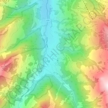
Name: Aschau topographic map, elevation, terrain.
Average elevation: 1,314 m
Minimum elevation: 940 m
Maximum elevation: 1,906 m
Make a donation
Gear up for your next adventure:
As an Amazon Associate, this site earns from qualifying purchases at no extra cost to you.
Other topographic maps
Click on a map to view its topography, its elevation and its terrain.
Oberes Dorf
Österreich > Tirol > Bezirk Kitzbühel > Marktgemeinde St. Johann in Tirol
Average elevation: 711 m
Make a donation
Gear up for your next adventure:
As an Amazon Associate, this site earns from qualifying purchases at no extra cost to you.
Kirchdorf
Österreich > Tirol > Bezirk Kitzbühel > Gemeinde Kirchdorf in Tirol
Average elevation: 1,009 m