Geolocate

O Cal topographic map

Click on the map to display elevation.

About this map

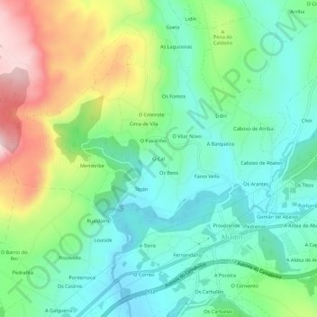
Name: O Cal topographic map, elevation, terrain.

Location: O Cal, Fanoi, Abadín, Tierra Chá, Lugo, Galicia, 27730, España (43.35358 -7.50797 43.39358 -7.46797)

Average elevation: 568 m

Minimum elevation: 456 m

Maximum elevation: 805 m

Other topographic maps

Click on a map to view its topography, its elevation and its terrain.

Moncelos

España > Galicia > Tierra Chá > Abadín

Average elevation: 443 m

Gear up for your next adventure:

🦯Trekking Poles - Reduced impact on joints for steep topographic climbs
🧦Merino Wool Socks - Moisture-wicking comfort for long-distance hiking
🌬️Windproof Camp Stove - Efficient cooking even on exposed mountain peaks
🥾Trekking Boots - Durable boots for long-distance trekking
🛌Insulated Sleeping Pad - Critical thermal barrier between you and the cold ground

As an Amazon Associate, this site earns from qualifying purchases at no extra cost to you.