
Make a donation
Gear up for your next adventure:
As an Amazon Associate, this site earns from qualifying purchases at no extra cost to you.
Joncy topographic map
Click on the map to display elevation.
Make a donation
Gear up for your next adventure:
As an Amazon Associate, this site earns from qualifying purchases at no extra cost to you.
About this map
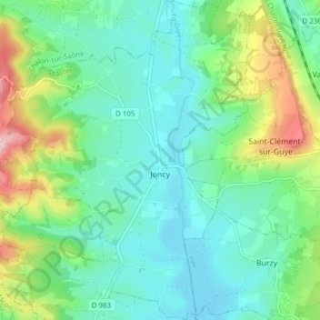
Name: Joncy topographic map, elevation, terrain.
Average elevation: 290 m
Minimum elevation: 222 m
Maximum elevation: 481 m
Make a donation
Gear up for your next adventure:
As an Amazon Associate, this site earns from qualifying purchases at no extra cost to you.
Other topographic maps
Click on a map to view its topography, its elevation and its terrain.
Commune
France > Bourgogne-Franche-Comté > Saône-et-Loire > Martigny-le-Comte
Average elevation: 353 m
Roche de Solutré
France > Bourgogne-Franche-Comté > Saône-et-Loire > Solutré-Pouilly > Solutré
Average elevation: 371 m
Layer
France > Bourgogne-Franche-Comté > Saône-et-Loire > Saint-Germain-du-Bois
Average elevation: 199 m
Saint-Pierre-de-Varennes
France > Bourgogne-Franche-Comté > Saône-et-Loire > Saint-Pierre-de-Varennes > Saint-Pierre-de-Varennes
Average elevation: 400 m
Make a donation
Gear up for your next adventure:
As an Amazon Associate, this site earns from qualifying purchases at no extra cost to you.
Étang de la Tour
France > Bourgogne-Franche-Comté > Saône-et-Loire > Saint-Firmin
Average elevation: 457 m
Les Croches
France > Bourgogne-Franche-Comté > Saône-et-Loire > Saint-Amour-Bellevue
Average elevation: 250 m
Les Longs Bois
France > Bourgogne-Franche-Comté > Saône-et-Loire > Saint-Forgeot
Average elevation: 305 m
Make a donation
Gear up for your next adventure:
As an Amazon Associate, this site earns from qualifying purchases at no extra cost to you.
Les Rues
France > Bourgogne-Franche-Comté > Saône-et-Loire > Fleury-la-Montagne
Average elevation: 376 m
Le Rousset
France > Bourgogne-Franche-Comté > Saône-et-Loire > Le Rousset-Marizy
Average elevation: 403 m
Make a donation
Gear up for your next adventure:
As an Amazon Associate, this site earns from qualifying purchases at no extra cost to you.
Make a donation
Gear up for your next adventure:
As an Amazon Associate, this site earns from qualifying purchases at no extra cost to you.
La Piat
France > Bourgogne-Franche-Comté > Saône-et-Loire > Saint-Amour-Bellevue
Average elevation: 243 m
Make a donation
Gear up for your next adventure:
As an Amazon Associate, this site earns from qualifying purchases at no extra cost to you.
Balme de Rochebin
France > Bourgogne-Franche-Comté > Saône-et-Loire > Azé > Montchanin
Average elevation: 305 m
Les Rompas
France > Bourgogne-Franche-Comté > Saône-et-Loire > Saint-Romain-sous-Gourdon
Average elevation: 361 m
Le Colombier
France > Bourgogne-Franche-Comté > Saône-et-Loire > Navour-sur-Grosne
Average elevation: 347 m
Make a donation
Gear up for your next adventure:
As an Amazon Associate, this site earns from qualifying purchases at no extra cost to you.
Les Vernes
France > Bourgogne-Franche-Comté > Saône-et-Loire > Saint-Bonnet-en-Bresse
Average elevation: 190 m
Les Crozes
France > Bourgogne-Franche-Comté > Saône-et-Loire > Saint-Igny-de-Roche
Average elevation: 421 m
Make a donation
Gear up for your next adventure:
As an Amazon Associate, this site earns from qualifying purchases at no extra cost to you.
Frêne
France > Bourgogne-Franche-Comté > Saône-et-Loire > Lournand > Sous Lourdon
Average elevation: 352 m
Make a donation
Gear up for your next adventure:
As an Amazon Associate, this site earns from qualifying purchases at no extra cost to you.
Make a donation
Gear up for your next adventure:
As an Amazon Associate, this site earns from qualifying purchases at no extra cost to you.
Martoret
France > Bourgogne-Franche-Comté > Saône-et-Loire > Saint-Maurice-de-Satonnay
Average elevation: 228 m
Robin
France > Bourgogne-Franche-Comté > Saône-et-Loire > Saint-Martin-de-Lixy
Average elevation: 350 m
Make a donation
Gear up for your next adventure:
As an Amazon Associate, this site earns from qualifying purchases at no extra cost to you.
Brancion
France > Bourgogne-Franche-Comté > Saône-et-Loire > Martailly-lès-Brancion
Average elevation: 303 m
Make a donation
Gear up for your next adventure:
As an Amazon Associate, this site earns from qualifying purchases at no extra cost to you.
Les Branles
France > Bourgogne-Franche-Comté > Saône-et-Loire > Curtil-sous-Buffières
Average elevation: 377 m
Le Montsacc
France > Bourgogne-Franche-Comté > Saône-et-Loire > Saint-Christophe-en-Brionnais
Average elevation: 431 m
Make a donation
Gear up for your next adventure:
As an Amazon Associate, this site earns from qualifying purchases at no extra cost to you.
Le Crot au Meunier
France > Bourgogne-Franche-Comté > Saône-et-Loire > La Grande-Verrière
Average elevation: 513 m
Make a donation
Gear up for your next adventure:
As an Amazon Associate, this site earns from qualifying purchases at no extra cost to you.
Arbain
France > Bourgogne-Franche-Comté > Saône-et-Loire > Savigny-sur-Seille
Average elevation: 191 m
Make a donation
Gear up for your next adventure:
As an Amazon Associate, this site earns from qualifying purchases at no extra cost to you.
Tunnel des Crottes
France > Bourgogne-Franche-Comté > Saône-et-Loire > La Clayette
Average elevation: 391 m
Make a donation
Gear up for your next adventure:
As an Amazon Associate, this site earns from qualifying purchases at no extra cost to you.
Champlong
France > Bourgogne-Franche-Comté > Saône-et-Loire > Dompierre-sous-Sanvignes
Average elevation: 301 m
Buis
France > Bourgogne-Franche-Comté > Saône-et-Loire > Saint-Léger-sous-Beuvray
Average elevation: 412 m
Les Rochettes
France > Bourgogne-Franche-Comté > Saône-et-Loire > Chasselas > Les Rochettes
Average elevation: 386 m
Make a donation
Gear up for your next adventure:
As an Amazon Associate, this site earns from qualifying purchases at no extra cost to you.
Le Lait
France > Bourgogne-Franche-Comté > Saône-et-Loire > La Comelle > Le Lait
Average elevation: 332 m
Chambois
France > Bourgogne-Franche-Comté > Saône-et-Loire > Tavernay > Chambois
Average elevation: 319 m
Make a donation
Gear up for your next adventure:
As an Amazon Associate, this site earns from qualifying purchases at no extra cost to you.
Diconne
France > Bourgogne-Franche-Comté > Saône-et-Loire > Diconne > Diconne
Average elevation: 207 m
Villemartin
France > Bourgogne-Franche-Comté > Saône-et-Loire > Saillenard > Villemartin
Average elevation: 204 m
Mouillargue
France > Bourgogne-Franche-Comté > Saône-et-Loire > Paray-le-Monial > Mouillargue
Average elevation: 265 m
Make a donation
Gear up for your next adventure:
As an Amazon Associate, this site earns from qualifying purchases at no extra cost to you.
Saint-Aubin-en-Charollais
France > Bourgogne-Franche-Comté > Saône-et-Loire > Saint-Aubin-en-Charollais > Saint-Aubin-en-Charollais
Average elevation: 282 m
Les Pignots
France > Bourgogne-Franche-Comté > Saône-et-Loire > Anost > Les Pignots
Average elevation: 598 m
La Faye
France > Bourgogne-Franche-Comté > Saône-et-Loire > Sanvignes-les-Mines > La Faye
Average elevation: 321 m
Mercey
France > Bourgogne-Franche-Comté > Saône-et-Loire > Cheilly-lès-Maranges > Mercey
Average elevation: 297 m
Make a donation
Gear up for your next adventure:
As an Amazon Associate, this site earns from qualifying purchases at no extra cost to you.
Essanley
France > Bourgogne-Franche-Comté > Saône-et-Loire > Gueugnon > Essanley
Average elevation: 273 m
Bas de Tronchy
France > Bourgogne-Franche-Comté > Saône-et-Loire > Tronchy > Bas de Tronchy
Average elevation: 201 m
La Maison Rouge
France > Bourgogne-Franche-Comté > Saône-et-Loire > Saint-Martin-de-Commune
Average elevation: 436 m
Soleil
France > Bourgogne-Franche-Comté > Saône-et-Loire > Saint-Symphorien-des-Bois > Soleil
Average elevation: 403 m
Make a donation
Gear up for your next adventure:
As an Amazon Associate, this site earns from qualifying purchases at no extra cost to you.
Charollais
France > Bourgogne-Franche-Comté > Saône-et-Loire > Vindecy > Charollais
Average elevation: 243 m
Les Raveaux
France > Bourgogne-Franche-Comté > Saône-et-Loire > Saint-Romain-sous-Versigny > Les Raveaux
Average elevation: 323 m
Haut de Rancy
France > Bourgogne-Franche-Comté > Saône-et-Loire > Rancy > Haut de Rancy
Average elevation: 186 m
Narfoux
France > Bourgogne-Franche-Comté > Saône-et-Loire > La Genête > Narfoux
Average elevation: 186 m
Make a donation
Gear up for your next adventure:
As an Amazon Associate, this site earns from qualifying purchases at no extra cost to you.
Frettechise
France > Bourgogne-Franche-Comté > Saône-et-Loire > La Chapelle-Thècle > Frettechise
Average elevation: 195 m
La Collange
France > Bourgogne-Franche-Comté > Saône-et-Loire > Nochize > La Collange
Average elevation: 280 m
Make a donation
Gear up for your next adventure:
As an Amazon Associate, this site earns from qualifying purchases at no extra cost to you.
Messey-le-Bois
France > Bourgogne-Franche-Comté > Saône-et-Loire > Messey-sur-Grosne
Average elevation: 208 m
Le Talochet
France > Bourgogne-Franche-Comté > Saône-et-Loire > Vitry-en-Charollais
Average elevation: 257 m
Make a donation
Gear up for your next adventure:
As an Amazon Associate, this site earns from qualifying purchases at no extra cost to you.
Les Teppes
France > Bourgogne-Franche-Comté > Saône-et-Loire > Saint-Symphorien-d'Ancelles
Average elevation: 178 m
Make a donation
Gear up for your next adventure:
As an Amazon Associate, this site earns from qualifying purchases at no extra cost to you.
Villeneuve
France > Bourgogne-Franche-Comté > Saône-et-Loire > Frangy-en-Bresse
Average elevation: 192 m
Make a donation
Gear up for your next adventure:
As an Amazon Associate, this site earns from qualifying purchases at no extra cost to you.