Geolocate

Gray topographic map

Click on the map to display elevation.

About this map
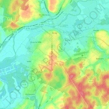
Name: Gray topographic map, elevation, terrain.

Location: Gray, Vesoul, Haute-Saône, Bourgogne-Franche-Comté, Metropolitan France, 70100, France (47.39495 5.57256 47.46721 5.65875)

Average elevation: 209 m

Minimum elevation: 183 m

Maximum elevation: 256 m

Other topographic maps

Click on a map to view its topography, its elevation and its terrain.
Vesoul

France > Bourgogne-Franche-Comté > Haute-Saône > Vesoul > Vesoul

Average elevation: 279 m

Gear up for your next adventure:

🧭GPS Outdoor Watch - Smart watch for navigation and fitness tracking in nature
🥾Waterproof Hiking Boots - Essential footwear for rugged terrain and wet Canadian trails
🥾Waterproof Hiking Boots - Boots keeping your feet dry in wet conditions
🔦UV Flashlight - Detect minerals or specific insects in the dark
🛏️Camping Sleeping Mat - Comfortable mats for sleeping outdoors

As an Amazon Associate, this site earns from qualifying purchases at no extra cost to you.