
Make a donation
Gear up for your next adventure:
As an Amazon Associate, this site earns from qualifying purchases at no extra cost to you.
Boulemane Province topographic map
Click on the map to display elevation.
Make a donation
Gear up for your next adventure:
As an Amazon Associate, this site earns from qualifying purchases at no extra cost to you.
About this map
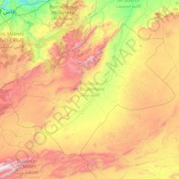
Name: Boulemane Province topographic map, elevation, terrain.
Location: Boulemane Province, Fez-Meknes, Morocco (32.60056 -5.02383 33.90957 -2.89900)
Average elevation: 1,335 m
Minimum elevation: 190 m
Maximum elevation: 3,688 m
Make a donation
Gear up for your next adventure:
As an Amazon Associate, this site earns from qualifying purchases at no extra cost to you.
Other topographic maps
Click on a map to view its topography, its elevation and its terrain.
Small Forest Type Land
Morocco > Cercle de Chichaoua دائرة شيشاوة > Sidi Bouzid Arragragui
Average elevation: 469 m
Make a donation
Gear up for your next adventure:
As an Amazon Associate, this site earns from qualifying purchases at no extra cost to you.
Douar Lekbir Draa Ben Chekra
Morocco > cercle de Hrara > Ahrara > Douar Lekbir Draa Ben Chekra
Average elevation: 93 m