Geolocate

Coffee topographic map

Click on the map to display elevation.

About this map

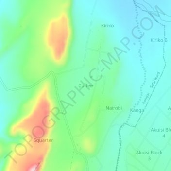
Name: Coffee topographic map, elevation, terrain.

Location: Coffee, Solai ward, Rongai, Nakuru, Rift Valley, Kenya (0.11643 36.20249 0.15643 36.24249)

Average elevation: 1,758 m

Minimum elevation: 1,690 m

Maximum elevation: 1,941 m

Other topographic maps

Click on a map to view its topography, its elevation and its terrain.

Lake Solai

Kenya > Nakuru > Rongai > Solai ward > Lekikor/Siriande

Average elevation: 1,525 m

Gear up for your next adventure:

🪜Heavy Duty Carabiners - Multi-use clips for securing gear to your backpack
🥾Hiking Shoes - Durable and comfortable shoes for trail hiking
🦶Hiking Shoe Insoles - Added support for high arches and long days on feet
🥽Outdoor Goggles - Protective eyewear for outdoor activities
👖Convertible Hiking Pants - Zip-off legs to adapt to changing weather conditions

As an Amazon Associate, this site earns from qualifying purchases at no extra cost to you.