Geolocate

Guarapuava topographic map

Click on the map to display elevation.

Guarapuava

Guarapuava is located at 25°23'36" south and 51°27'19" west. The region is known as the centre of the state of Paraná, in the third plateau, also called the Plateau of Guarapuava. Discovered by the Portuguese in 1770, and founded in 1810, the city's name comes from tupi guarani, meaning place of Maned wolves sound (Maned wolves are called Lobos-guará in Portuguese). Its elevation is 1120 m (3675 ft).

Wikipedia (CC-BY-SA 3.0)

About this map

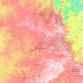
Name: Guarapuava topographic map, elevation, terrain.

Location: Guarapuava, Região Geográfica Imediata de Guarapuava, Região Geográfica Intermediária de Guarapuava, Paraná, South Region, Brazil (-25.68198 -52.02337 -24.96973 -51.08968)

Average elevation: 1,001 m

Minimum elevation: 490 m

Maximum elevation: 1,355 m

Gear up for your next adventure:

🥾Trail Hiking Shoes - Durable shoes designed for rugged trails
🧢Sun Protection Cap - Breathable cap to protect from sun exposure
🧭Orienteering Kit - Tools for map reading and navigation in the wild
🔭Compact Monocular - One-handed bird watching and trail spotting
🕯️Camping Lantern - Illuminates your entire campsite with high-efficiency LEDs

As an Amazon Associate, this site earns from qualifying purchases at no extra cost to you.