Geolocate

Toledo topographic map

Click on the map to display elevation.

About this map

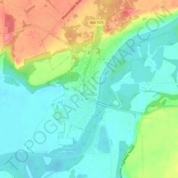
Name: Toledo topographic map, elevation, terrain.

Location: Toledo, Lewis County, Washington, United States (46.43233 -122.85724 46.44933 -122.84193)

Average elevation: 49 m

Minimum elevation: 21 m

Maximum elevation: 103 m

Other topographic maps

Click on a map to view its topography, its elevation and its terrain.

Bremer

United States > Washington > Lewis County

Average elevation: 430 m

Pompey Peak

United States > Washington > Lewis County

Average elevation: 1,156 m

Packwood

United States > Washington > Lewis County

Average elevation: 379 m

Mineral

United States > Washington > Lewis County > Mineral

Average elevation: 481 m

Onalaska

United States > Washington > Lewis County

Average elevation: 170 m

Adna

United States > Washington > Lewis County

Average elevation: 82 m

Narada Falls

United States > Washington > Lewis County

Average elevation: 1,444 m

Vader

United States > Washington > Lewis County

Average elevation: 74 m

Glenoma

United States > Washington > Lewis County

Average elevation: 354 m

Chimney Rock

United States > Washington > Lewis County

Average elevation: 1,593 m

Gear up for your next adventure:

🧣Merino Neck Gaiter - Protects against wind, sun, and cold at high altitudes
Tent Footprint - Protect tent floor and increase durability
🧰Emergency Multi-Tool - Compact multi-tool for outdoor survival
🔦LED Headlamp - Hands-free lighting for early morning starts or late finishes
👟Sport Hiking Sandals - Breathable footwear for water crossings and camp rest

As an Amazon Associate, this site earns from qualifying purchases at no extra cost to you.