
Make a donation
Gear up for your next adventure:
As an Amazon Associate, this site earns from qualifying purchases at no extra cost to you.
Pincourt topographic map
Click on the map to display elevation.
Make a donation
Gear up for your next adventure:
As an Amazon Associate, this site earns from qualifying purchases at no extra cost to you.
About this map
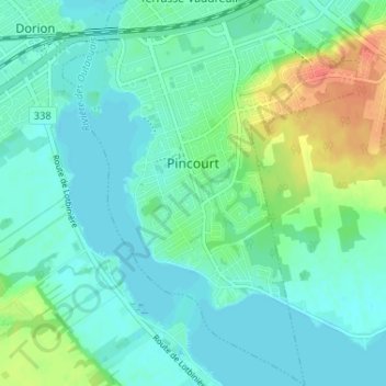
Name: Pincourt topographic map, elevation, terrain.
Location: Pincourt, Vaudreuil-Soulanges, Montérégie, Quebec, Canada (45.34490 -74.00802 45.39046 -73.95814)
Average elevation: 31 m
Minimum elevation: 19 m
Maximum elevation: 65 m
Vaudreuil-Soulanges trails, hiking, mountain biking, running and outdoor activities
Make a donation
Gear up for your next adventure:
As an Amazon Associate, this site earns from qualifying purchases at no extra cost to you.
Other topographic maps
Click on a map to view its topography, its elevation and its terrain.
Saint-Lazare
Canada > Quebec > Vaudreuil-Soulanges > Saint-Lazare > Saint-Lazare
Average elevation: 64 m
Domaine du Lac
Canada > Quebec > Vaudreuil-Soulanges > Notre-Dame-de-l'Île-Perrot
Average elevation: 27 m