
Bella Vista topographic map
Click on the map to display elevation.
Bella Vista
Bella Vista is a city in Benton County, Arkansas, United States. The community has taken advantage of the natural setting within the Springfield Plateau of the Ozark Mountains since first established in 1917 as a summer resort destination. The oak/hickory forests, valleys, creeks, and steep rises that characterize the city's topography have slowly given way to a series of reservoirs, golf courses, and other amenities. A largely residential city, early settlement was predominantly summer cabins, later giving way to single-family housing of a retirement community developed by Cooper Communities with services and amenities provided by a strong property owners' association (POA).
About this map
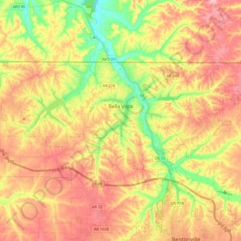
Name: Bella Vista topographic map, elevation, terrain.
Location: Bella Vista, Benton County, Arkansas, 72715, United States (36.41540 -94.37568 36.49960 -94.16197)
Average elevation: 372 m
Minimum elevation: 283 m
Maximum elevation: 447 m
Other topographic maps
Click on a map to view its topography, its elevation and its terrain.
Bentonville
United States > Arkansas > Benton County > Bentonville > Bentonville
Bentonville lies in the humid subtropical climate zone (Köppen Cfa) with influence from the humid continental climate type. Bentonville experiences all four seasons and does receive cold air masses from the north, however some of the Arctic masses are blocked by the higher elevations of the Ozarks. July is…
Average elevation: 383 m
Blowing Springs Bike & Fitness Park
United States > Arkansas > Benton County > Bella Vista
Average elevation: 351 m