Geolocate

Gothicville topographic map

Click on the map to display elevation.

About this map

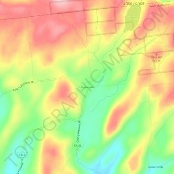
Name: Gothicville topographic map, elevation, terrain.

Location: Gothicville, Town of Decatur, Otsego County, New York, United States (42.65313 -74.71320 42.69313 -74.67320)

Average elevation: 615 m

Minimum elevation: 524 m

Maximum elevation: 695 m

Other topographic maps

Click on a map to view its topography, its elevation and its terrain.

Town of Oneonta

United States > New York > Otsego County

Average elevation: 456 m

City of Oneonta

United States > New York > Otsego County

Average elevation: 433 m

City of Oneonta

United States > New York > Otsego County

Average elevation: 433 m

City of Oneonta

United States > New York > Otsego County

Average elevation: 433 m

Town of Otego

United States > New York > Otsego County

Average elevation: 453 m

Gear up for your next adventure:

🧥Ultralight Puffy Jacket - Maximum warmth that packs down to the size of an orange
🦯Trekking Poles - Reduced impact on joints for steep topographic climbs
🧊Insulated Water Bottle - Keeps drinks cold in summer and prevents freezing in winter
🔦LED Headtorch - Bright and durable light for night activities
🥾Mountain Hiking Shoes - Shoes with superior grip for mountainous terrain

As an Amazon Associate, this site earns from qualifying purchases at no extra cost to you.