Geolocate

Red House topographic map

Click on the map to display elevation.

About this map

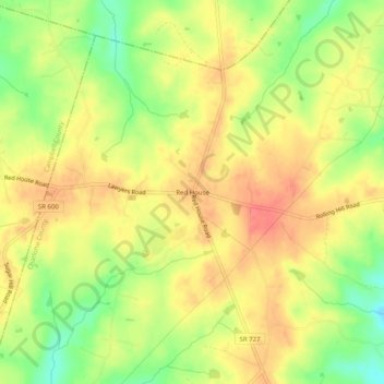
Name: Red House topographic map, elevation, terrain.

Location: Red House, Charlotte County, Virginia, 23963, United States (37.16913 -78.83196 37.20913 -78.79196)

Average elevation: 215 m

Minimum elevation: 177 m

Maximum elevation: 242 m

Other topographic maps

Click on a map to view its topography, its elevation and its terrain.

Keysville

United States > Virginia > Charlotte County

Average elevation: 187 m

Phenix

United States > Virginia > Charlotte County

Average elevation: 133 m

Gear up for your next adventure:

🥾Hiking Boots - Sturdy boots providing ankle support and traction on rugged trails
🧥Softshell Hiking Jacket - The perfect balance of wind protection and breathability
🗺️Topographic Maps - Detailed maps to explore trails, mountains, and wilderness areas
🥾Hiking Shorts - Breathable shorts suitable for summer hikes
🥫Freeze-Dried Meals - Lightweight, high-calorie nutrition for multi-day treks

As an Amazon Associate, this site earns from qualifying purchases at no extra cost to you.