Geolocate

Curca topographic map

Click on the map to display elevation.

About this map

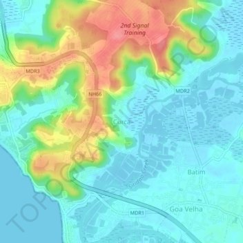
Name: Curca topographic map, elevation, terrain.

Location: Curca, Tiswadi, North Goa, Goa, 403203, India (15.43532 73.85075 15.47532 73.89075)

Average elevation: 25 m

Minimum elevation: -2 m

Maximum elevation: 88 m

Other topographic maps

Click on a map to view its topography, its elevation and its terrain.

Divar Island

India > Goa > Tiswadi > Naroa

Average elevation: 11 m

Miramar Beach

India > Goa > Tiswadi > Panaji

Average elevation: 3 m

Mala Lake

India > Goa > Tiswadi > Panaji

Average elevation: 10 m

Divar Island

India > Goa > Tiswadi > Piedade

Average elevation: 11 m

Chorão Island

India > Goa > Tiswadi > Chorao

Average elevation: 13 m

Gear up for your next adventure:

💡Portable Camping Lamp - Rechargeable lamp for campsite lighting
🏕️Camping Hammock - Integrated protection for sleeping between trees
🥾Trail Hiking Boots - Supportive boots for rough trails
💧Reusable Water Bottle - Durable water bottles for hydration on trails
🥤Collapsible Travel Cup - Saves space and weight in your mess kit

As an Amazon Associate, this site earns from qualifying purchases at no extra cost to you.