Geolocate

Badoc topographic map

Click on the map to display elevation.

Badoc

The celebrated Philippine painter Juan Luna was baptized in Badoc Church on 27 October 1857. At present, the church houses the miraculous statue of the Blessed Virgin Mary venerated under the title Virgin of Miracles, crowned by Catholic bishops in 1980, and was granted a Canonical coronation by Pope Francis on 31 May 2018. On November 30, 2018, the parish was elevated to the level of a Minor Basilica. The elevation rites took place on February 5, 2019.

Wikipedia (CC-BY-SA 3.0)

About this map

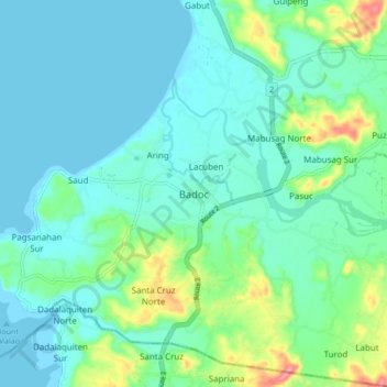
Name: Badoc topographic map, elevation, terrain.

Location: Badoc, Ilocos Norte, Ilocos Region, 2733, Philippines (17.88670 120.43409 17.96670 120.51409)

Average elevation: 20 m

Minimum elevation: 0 m

Maximum elevation: 94 m

Other topographic maps

Click on a map to view its topography, its elevation and its terrain.

Pinili

Philippines > Ilocos Norte

Average elevation: 69 m

Pagudpud

Philippines > Ilocos Norte

The town's topography includes mountains, hills, valleys and flat coastal land.

Average elevation: 71 m

Brgy. 43- Cavit

Philippines > Ilocos Norte

Average elevation: 4 m

Brgy. 11

Philippines > Ilocos Norte

Average elevation: 11 m

Brgy. 6

Philippines > Ilocos Norte

Average elevation: 10 m

Bojeador Cape

Philippines > Ilocos Norte

Average elevation: 114 m

Badoc Island

Philippines > Ilocos Norte

Average elevation: 1 m

Luna Park

Philippines > Ilocos Norte > Garreta

Average elevation: 16 m

Paoay Lake

Philippines > Ilocos Norte > Suba

Average elevation: 26 m

Saud Beach

Philippines > Ilocos Norte > Pagudpud > Saud

Average elevation: 11 m

Gasgas River

Philippines > Ilocos Norte > Foz

Average elevation: 219 m

Pinili

Philippines > Ilocos Norte

Average elevation: 69 m

Pinili

Philippines > Ilocos Norte

Average elevation: 69 m

Saud Beach

Philippines > Ilocos Norte > Pagudpud > Saud

Average elevation: 11 m

Brgy. 1

Philippines > Ilocos Norte

Average elevation: 10 m

Pagudpud

Philippines > Ilocos Norte

The town's topography includes mountains, hills, valleys and flat coastal land.

Average elevation: 73 m

Gear up for your next adventure:

🥘Camping Cookware Set - Compact nesting pots and pans for trail cooking
🧊Portable Cooler - Keep food and drinks cold during outdoor adventures
🧰Survival Kit - Essential gear for emergencies in the wilderness
🧤Thermal Hiking Gloves - Grip-enhanced gloves for cold-weather altitude trekking
🧊Insulated Water Bottle - Keeps drinks cold in summer and prevents freezing in winter

As an Amazon Associate, this site earns from qualifying purchases at no extra cost to you.