Geolocate

Upper Brookfield topographic map

Click on the map to display elevation.

About this map

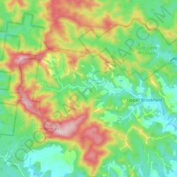
Name: Upper Brookfield topographic map, elevation, terrain.

Location: Upper Brookfield, City of Brisbane, Queensland, Australia (-27.50331 152.80993 -27.44306 152.89296)

Average elevation: 191 m

Minimum elevation: 54 m

Maximum elevation: 415 m

Other topographic maps

Click on a map to view its topography, its elevation and its terrain.

Bulimba Creek

Australia > Queensland > City of Brisbane

Average elevation: 11 m

Tangalooma

Australia > Queensland > City of Brisbane

Average elevation: 41 m

Enoggera Hill

Australia > Queensland > City of Brisbane

Average elevation: 114 m

Enoggera Dam

Australia > Queensland > City of Brisbane

Average elevation: 90 m

Blunder Creek

Australia > Queensland > City of Brisbane

Average elevation: 26 m

Tangalooma

Australia > Queensland > City of Brisbane

Average elevation: 41 m

Gear up for your next adventure:

🥾Trail Running Boots - Durable shoes designed for trail running
🧢Sun Protection Cap - Breathable cap to protect from sun exposure
🔥Camping Stove - Portable stoves to cook outdoors with ease
🔋Lithium AA Batteries - Long-lasting power that performs in extreme cold
🔦UV Flashlight - Detect minerals or specific insects in the dark

As an Amazon Associate, this site earns from qualifying purchases at no extra cost to you.