Geolocate

Palat topographic map

Click on the map to display elevation.

About this map

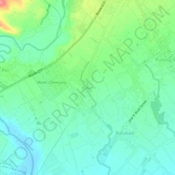
Name: Palat topographic map, elevation, terrain.

Location: Palat, Porac, Pampanga, Central Luzon, 2008, Philippines (15.02344 120.51801 15.06344 120.55801)

Average elevation: 58 m

Minimum elevation: 32 m

Maximum elevation: 123 m

Other topographic maps

Click on a map to view its topography, its elevation and its terrain.

Miyamit Falls

Philippines > Pampanga > Porac

Average elevation: 807 m

Barangay Dolores Plaza

Philippines > Pampanga > Porac

Average elevation: 133 m

Gear up for your next adventure:

👟Trail Running Shoes - Agile footwear for fast-paced topographic exploration
🧴Sunscreen SPF - Broad-spectrum sunscreen for outdoor activities
🥤Collapsible Travel Cup - Saves space and weight in your mess kit
🪑Insulated Seat Pad - Protect your seat from cold rocks and wet logs
Camping Coffee Maker - Brew fresh coffee anywhere on the topographic map

As an Amazon Associate, this site earns from qualifying purchases at no extra cost to you.