
Make a donation
Gear up for your next adventure:
As an Amazon Associate, this site earns from qualifying purchases at no extra cost to you.
Palau-sator topographic map
Click on the map to display elevation.
Make a donation
Gear up for your next adventure:
As an Amazon Associate, this site earns from qualifying purchases at no extra cost to you.
About this map
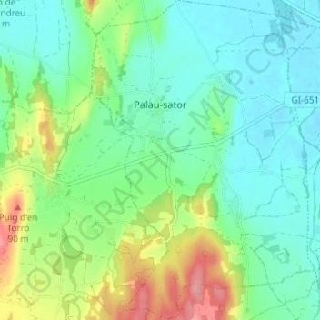
Name: Palau-sator topographic map, elevation, terrain.
Location: Palau-sator, Baix Empordà, Gerona, Catalonië, Spanje (41.95931 3.09723 42.00462 3.14022)
Average elevation: 30 m
Minimum elevation: -1 m
Maximum elevation: 100 m
Make a donation
Gear up for your next adventure:
As an Amazon Associate, this site earns from qualifying purchases at no extra cost to you.
Other topographic maps
Click on a map to view its topography, its elevation and its terrain.
Cruïlles
Spanje > Catalonië > Baix Empordà > Cruïlles, Monells i Sant Sadurní de l'Heura
Average elevation: 66 m
Make a donation
Gear up for your next adventure:
As an Amazon Associate, this site earns from qualifying purchases at no extra cost to you.
Platja d'Aro
Spanje > Catalonië > Baix Empordà > Castell d'Aro, Platja d'Aro i s'Agaró
Average elevation: 47 m
Make a donation
Gear up for your next adventure:
As an Amazon Associate, this site earns from qualifying purchases at no extra cost to you.