Geolocate

San Jose topographic map

Click on the map to display elevation.

About this map

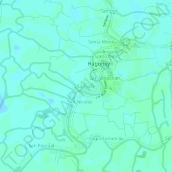
Name: San Jose topographic map, elevation, terrain.

Location: San Jose, Hagonoy, Bulacan, Central Luzon, 2017, Philippines (14.81030 120.71043 14.85030 120.75043)

Average elevation: 3 m

Minimum elevation: -2 m

Maximum elevation: 5 m

Other topographic maps

Click on a map to view its topography, its elevation and its terrain.

Pugad

Philippines > Bulacan > Hagonoy

Average elevation: 2 m

Angat River

Philippines > Bulacan > Hagonoy > Iba-Ibayo

Average elevation: 4 m

Mercado

Philippines > Bulacan > Hagonoy

Average elevation: 3 m

Pugad

Philippines > Bulacan > Hagonoy

Average elevation: 2 m

Gear up for your next adventure:

🔥Camping Stove - Portable stoves to cook outdoors with ease
🛌Down Sleeping Bag - Superior warmth-to-weight ratio for cold nights
🌡️Emergency Mylar Blankets - Compact thermal protection for unexpected nights outdoors
🛶Kayak Dry Bag - Waterproof storage for kayaking adventures
👟Leg Gaiters - Keep debris, mud, and snow out of your boots

As an Amazon Associate, this site earns from qualifying purchases at no extra cost to you.