
Thank you for supporting this site ❤️
Make a donation
Make a donation
Gear up for your next adventure:
As an Amazon Associate, this site earns from qualifying purchases at no extra cost to you.
Wussan topographic map
Click on the map to display elevation.
Thank you for supporting this site ❤️
Make a donation
Make a donation
Gear up for your next adventure:
As an Amazon Associate, this site earns from qualifying purchases at no extra cost to you.
About this map
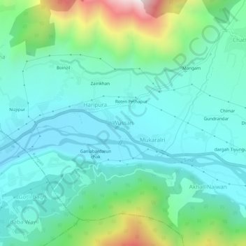
Name: Wussan topographic map, elevation, terrain.
Location: Wussan, Kangan, Ganderbal, Jammu and Kashmir, 191201, India (34.26771 74.82283 34.30771 74.86283)
Average elevation: 1,893 m
Minimum elevation: 1,677 m
Maximum elevation: 2,648 m
Thank you for supporting this site ❤️
Make a donation
Make a donation
Gear up for your next adventure:
As an Amazon Associate, this site earns from qualifying purchases at no extra cost to you.