
Thank you for supporting this site ❤️
Make a donation
Make a donation
Gear up for your next adventure:
As an Amazon Associate, this site earns from qualifying purchases at no extra cost to you.
Wolkrange topographic map
Click on the map to display elevation.
Thank you for supporting this site ❤️
Make a donation
Make a donation
Gear up for your next adventure:
As an Amazon Associate, this site earns from qualifying purchases at no extra cost to you.
About this map
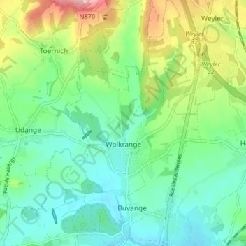
Name: Wolkrange topographic map, elevation, terrain.
Location: Wolkrange, Messancy, Arlon, Luxembourg, Wallonie, Belgique (49.61727 5.77507 49.66006 5.81917)
Average elevation: 334 m
Minimum elevation: 286 m
Maximum elevation: 442 m
Thank you for supporting this site ❤️
Make a donation
Make a donation
Gear up for your next adventure:
As an Amazon Associate, this site earns from qualifying purchases at no extra cost to you.