
Thank you for supporting this site ❤️
Make a donation
Make a donation
Gear up for your next adventure:
As an Amazon Associate, this site earns from qualifying purchases at no extra cost to you.
O Viveiró topographic map
Click on the map to display elevation.
Thank you for supporting this site ❤️
Make a donation
Make a donation
Gear up for your next adventure:
As an Amazon Associate, this site earns from qualifying purchases at no extra cost to you.
About this map
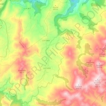
Name: O Viveiró topographic map, elevation, terrain.
Location: O Viveiró, Muras, Tierra Chá, Lugo, Galicia, 27837, España (43.44367 -7.65527 43.52536 -7.58392)
Average elevation: 695 m
Minimum elevation: 342 m
Maximum elevation: 1,029 m
Thank you for supporting this site ❤️
Make a donation
Make a donation
Gear up for your next adventure:
As an Amazon Associate, this site earns from qualifying purchases at no extra cost to you.
Other topographic maps
Click on a map to view its topography, its elevation and its terrain.