
Make a donation
Gear up for your next adventure:
As an Amazon Associate, this site earns from qualifying purchases at no extra cost to you.
Aubigny topographic map
Click on the map to display elevation.
Make a donation
Gear up for your next adventure:
As an Amazon Associate, this site earns from qualifying purchases at no extra cost to you.
Aubigny
Le territoire municipal d’Aubigny s’étend sur 2 599 hectares. L’altitude moyenne de la commune est de 62 mètres, avec des niveaux fluctuant entre 33 et 77 mètres.
Make a donation
Gear up for your next adventure:
As an Amazon Associate, this site earns from qualifying purchases at no extra cost to you.
About this map
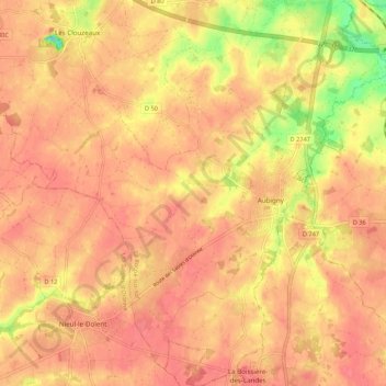
Name: Aubigny topographic map, elevation, terrain.
Average elevation: 64 m
Minimum elevation: 23 m
Maximum elevation: 77 m
Make a donation
Gear up for your next adventure:
As an Amazon Associate, this site earns from qualifying purchases at no extra cost to you.
Other topographic maps
Click on a map to view its topography, its elevation and its terrain.
La Soulinière
France > Pays de la Loire > Vendée > Aubigny-Les Clouzeaux > Les Clouzeaux
Average elevation: 54 m
Make a donation
Gear up for your next adventure:
As an Amazon Associate, this site earns from qualifying purchases at no extra cost to you.
Pont de Naillers
France > Pays de la Loire > Vendée > Aubigny-Les Clouzeaux > Les Clouzeaux > Le Moréchet
Average elevation: 53 m