
Thank you for supporting this site ❤️
Make a donation
Make a donation
Gear up for your next adventure:
As an Amazon Associate, this site earns from qualifying purchases at no extra cost to you.
Izaña topographic map
Click on the map to display elevation.
Thank you for supporting this site ❤️
Make a donation
Make a donation
Gear up for your next adventure:
As an Amazon Associate, this site earns from qualifying purchases at no extra cost to you.
About this map
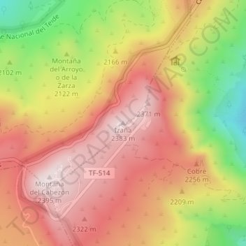
Name: Izaña topographic map, elevation, terrain.
Location: Izaña, La Orotava, Santa Cruz de Tenerife, Canarias, España (28.30720 -16.50219 28.30730 -16.50209)
Average elevation: 2,173 m
Minimum elevation: 1,851 m
Maximum elevation: 2,387 m
Thank you for supporting this site ❤️
Make a donation
Make a donation
Gear up for your next adventure:
As an Amazon Associate, this site earns from qualifying purchases at no extra cost to you.