Geolocate

Latte topographic map

Click on the map to display elevation.

About this map

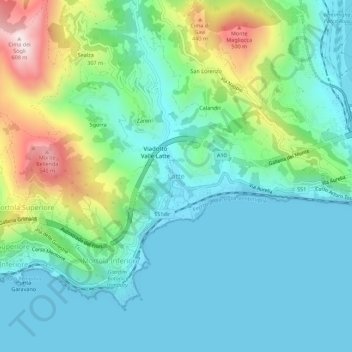
Name: Latte topographic map, elevation, terrain.

Location: Latte, Ventimiglia, Provincia di Imperia, Liguria, 19039, Italy (43.77494 7.54394 43.81494 7.58394)

Average elevation: 145 m

Minimum elevation: -1 m

Maximum elevation: 591 m

Gear up for your next adventure:

🧥Waterproof Jacket - Lightweight rain jackets for hiking and outdoor activities
💧Hydration Pack - Hands-free hydration system for long hikes
🧭Orienteering Kit - Tools for map reading and navigation in the wild
Camping Essentials - All-in-one gear for a comfortable camping trip
Backpacking Tent - Lightweight tent for long-distance hiking trips

As an Amazon Associate, this site earns from qualifying purchases at no extra cost to you.